Hardware + software · 2026
Airfield bird radar — detect, measure, analyse, deter
S-band bird detection radar for airfield bird-strike protection: 24-hour PPI monitoring, automatic range, speed, height and angle, bird activity analytics, and a radar series covering drones, birds, perimeter and traffic.
The situation
Bird strike risk on an airfield is concentrated where it is least forgiving: take-off and landing, at low altitude, where a bird is large relative to the margin available. The traditional control is a person with binoculars and a radio, and it works in daylight with good visibility — which is exactly not the whole problem, since a large share of the risk sits in the hours when a lookout cannot see.
Radar sensing is the obvious answer, and the naive version of it fails for a reason that has nothing to do with how far the radar can see: small radar cross-section, slow targets, and ground and weather clutter. A bird return is weak and intermittent, and everything else on the site returns something too.
The call we made
False alarms are the product decision, not detection range. In this application, a radar that reports twenty tracks an hour of which three are birds is switched off within a month, and then the risk is exactly as unmanaged as before. So the work went into low, slow and small target detection with clutter suppression, AI signal processing trained on measured data to raise detection and cut false alarm, graded alarms, and classification into large, medium and small so an operator can triage. Range on a specification sheet is the least interesting number here.
Detection without deterrence is a log file. The system links to airfield deterrents, and the intended loop is detect, identify, deter. The operational saving is a lookout post; the safety saving is that deterrence can be triggered on the target rather than on the schedule. The loop is only credible if the deterrent responds automatically, so the linkage is designed in rather than added by the buyer.
Radar cannot tell you what the bird is, and that gap is structural. So the next step in the line was distributed photoelectric coverage that fills in the areas radar cannot resolve, letting safety staff see an intrusion on video in real time, with AI classifying bird type and count, and birds activity data accumulating for analysis. Two sensors with different failure modes are worth more than one sensor with a better number.
A series, not a one-off installation. The radar front end, signal processing, AI recognition and data distribution are a shared base; frequency band, antenna gain, detection range and scan mode are the parameters that change per application. That gives the same platform a drone detection radar, a bird radar, a perimeter intrusion radar, a traffic flow monitor and a coastal and border surveillance radar. A one-off airfield radar is a project; a series is a product with support behind it.
Say who owns the capability. This hardware capability is held jointly by our core team and long-term technical partners. It is a cooperative capability, not a proprietary product line; specifications and delivery commitments are agreed per project with those partners. That belongs before the specification table, not in a footnote.
What we built
- Monitoring. 24-hour unattended bird activity monitoring, effective at night and in low visibility, replacing a human lookout as the persistent sensor.
- Measurement. Automatic range, speed, height and angle per target, producing structured airspace data rather than an image.
- Analysis. Bird activity analytics across eight chart families — hotspot distribution, track distribution, target counts, weather correlation, regional target index, entry and exit statistics, target type radar and day-night ratio — so time-of-day, altitude and migration patterns become visible.
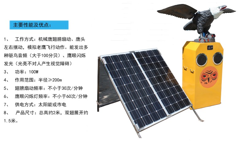
- Linkage. Radar with photoelectric fill-in and deterrent control, including gas cannon and solar sonic units with wing motion, audio above 100 dB and visible eagle-eye lighting at 200 metres or more; the multi-stimulus approach exists because birds habituate to a single one.
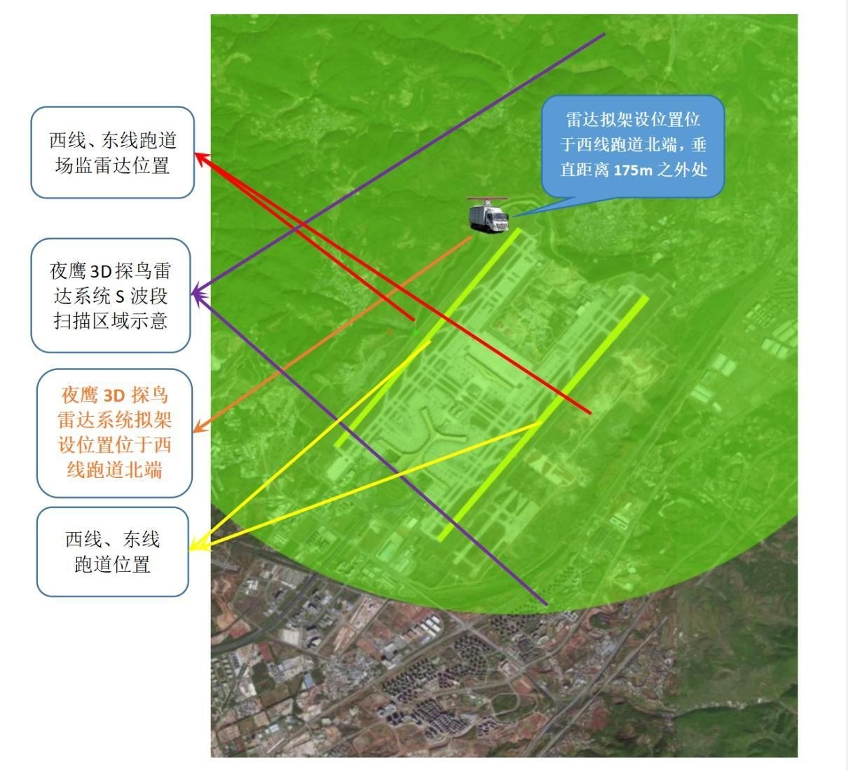
- Siting. Coverage and position studies over airfield imagery, including offset from the runway and scan sector, because a radar mounted in the wrong place cannot be fixed in software.
The system was developed and tested at an airport, which is the part that matters: measured clutter is the only kind that counts.
Result
The capability is delivered and field-tested, with the detected-and-deterred loop running and bird activity data accumulating instead of being thrown away. The siting studies turn the radar from a catalogue purchase into an installation that can be argued about with evidence.
The honest limits: radar alone cannot identify species, which is why the photoelectric layer exists; performance depends on siting and on the local clutter environment, so no coverage claim survives being copied from another site; and radio transmission is a regulated matter, with frequency approvals per jurisdiction that must be settled before a proposal, not after.

Technology
| Stack | S-band radar front end · PPI display · AI signal processing · Photoelectric sensors · Deterrent control · 4G link |
|---|---|
| Delivery model | Cooperative capability: developed and field-tested |
| Client | Airfield and critical-site operators |
| Status | Delivered |
What we cannot show
Hardware capability held jointly with long-term technical partners: cooperative, not a proprietary product line, and hardware specifications or delivery dates are not committed under our own name. Two PPI screenshots in the asset library are captures of a player window rather than clean system output and were deliberately not used.
Similar problem?
If this looks like something you are dealing with — a legacy system that must keep running, a workflow no product covers, an integration nobody wants to touch — send a short description. We will tell you honestly whether we are the right team, and what the first two weeks would look like.